Being blessed with beautiful mountains and breathtaking scenery, there are many best hiking places in Pakistan. The soul that seeks adventure often finds hiking in Pakistan fulfilling.
A country of majestic beauty, Pakistan is blessed with some of the most thrilling and adventurous trekking places. Moreover, the variety of tracks here is huge.
Whether you are a professional hiker or just starting an adventure, you will find a perfect place that supports your stamina.
We have compiled a list of the top 10 hiking places in Pakistan that you can travel to. Considering the difference in liking, you will find something that interests everyone.
Why Go Trekking/Hiking In Pakistan?
Before knowing about the best places, the question that comes to mind is why Pakistan? Indeed there are a lot of places in the world that you can go to. What makes Pakistan special for hiking?
Pakistan is blessed with breathtaking scenery.
With almost 5 of the world’s most famous peaks, Pakistan stands out in Asia. It provides tourists with the best experience. If you are a foreigner, there is a good chance of you being showered with hospitality and love no matter where you go in the country.
The hiking tracks here differentiate from easy to difficult levels and thus can support hikers of all capacities and age groups.
Best Hiking Destinations in Pakistan
- Fairy Medows And Nanga Parbat Base Camp
- Margalla Hills
- Passu To Borith Lake
- Nalter Valley
- Minapin To Rakaposhi Base Camp
- Kel To Taobat (Gurez Valley)
- Dunga Gali-Ayubia Track
- Chitta Katha Lake
- K2 Base Camp
- Snow Lake
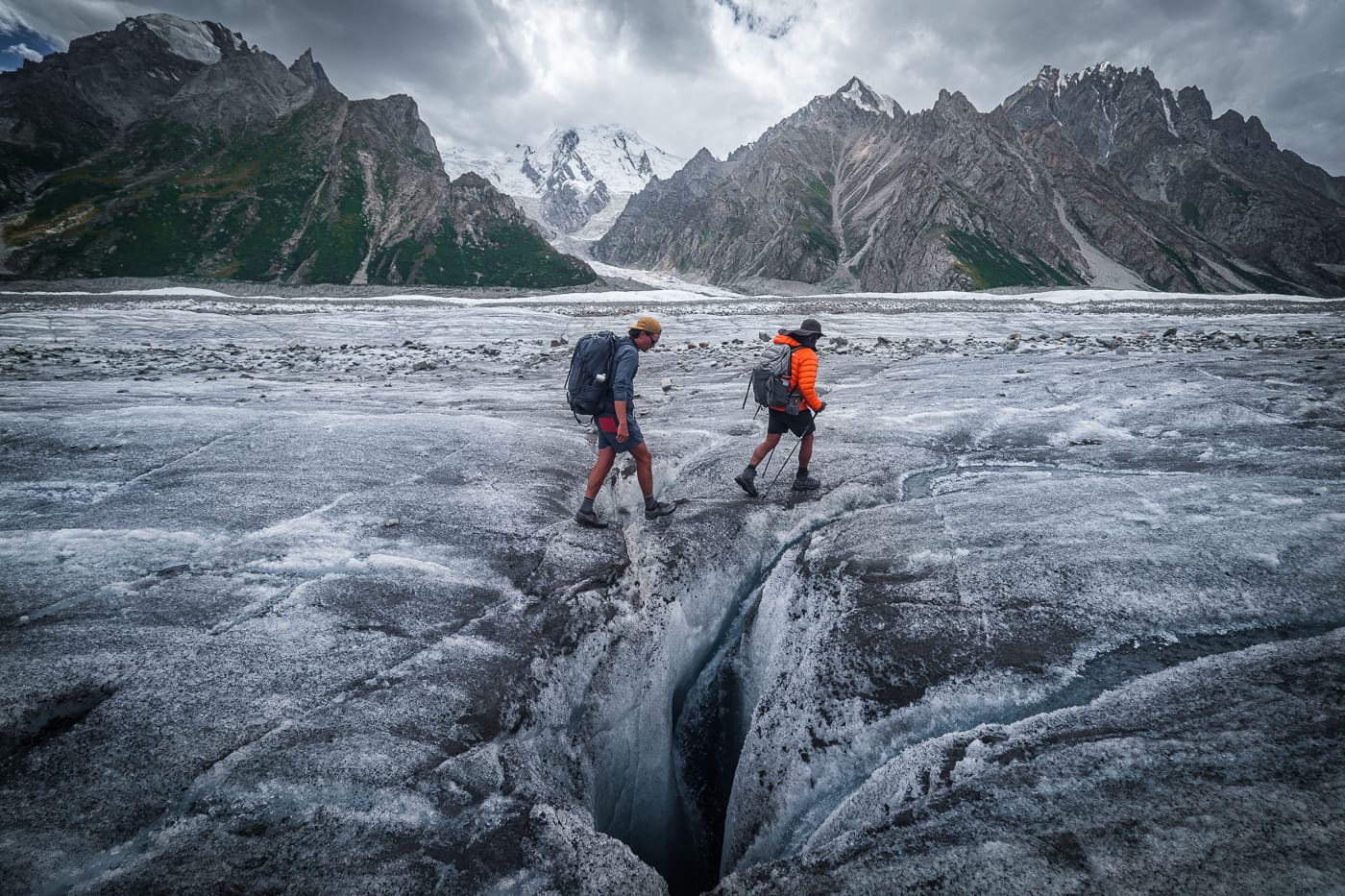
K2 Base Camp
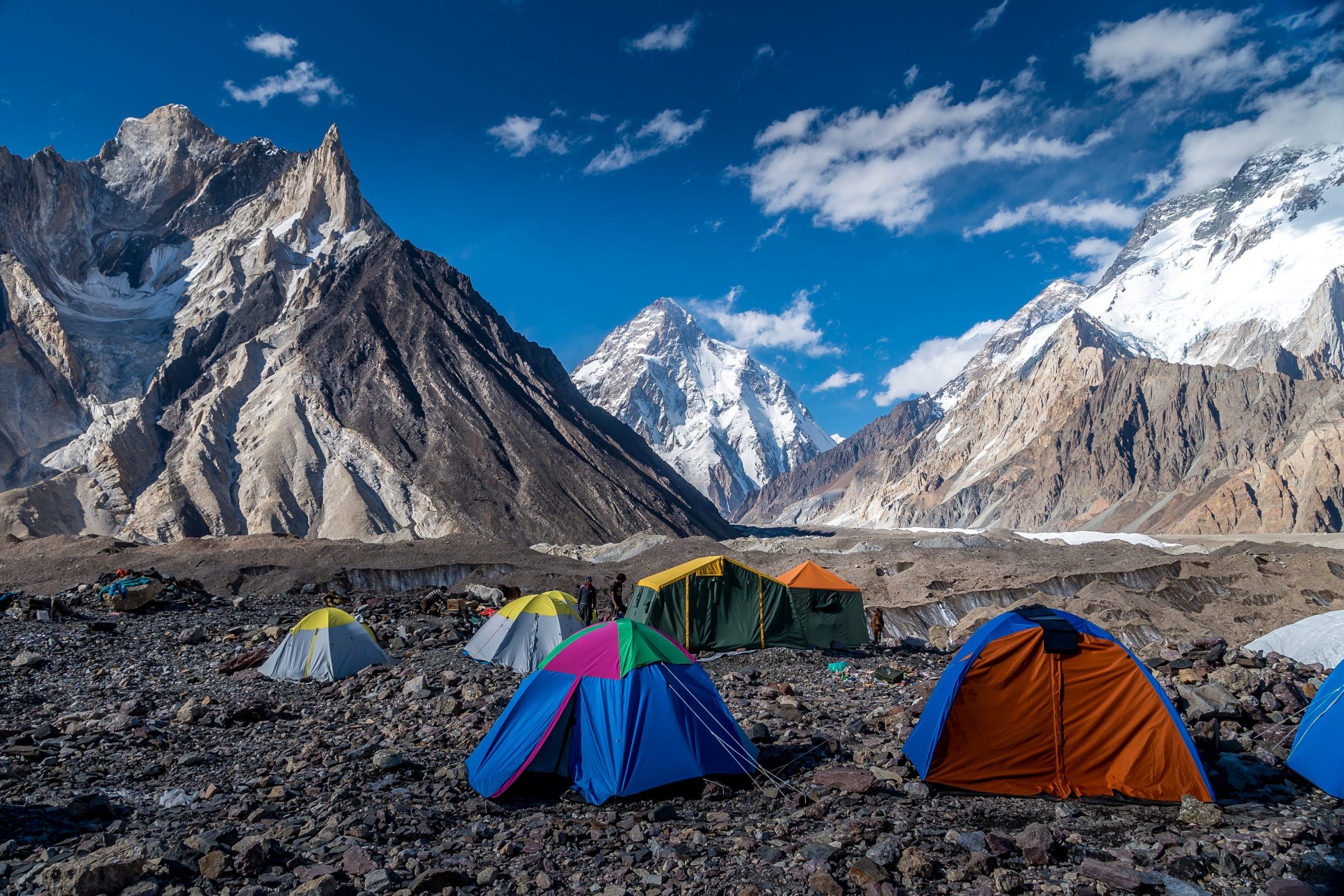
Are you a professional Hiker looking for something challenging? If so, K2 Base camp is a perfect hiking place in Pakistan. It is known as the monster hike of Pakistan.
Situated in the Karakoram national park, the hike here will need you to have a permit. Since the hike is of a professional level, the foreigners must accompany the guide along with a permit.
It might sound dangerous but it is among the most famous adventures in the world. Hikers from all around the world fly to Pakistan to hike on K2.
monster of all Pakistani hikes. It wouldn’t be wrong to call this hike the most thrilling in Asia.
How To Reach K2 Base Camp
The journey to K2 Base Camp starts from Askole, a small village in Kasmir. From the village, you will be hiking for a few days. You will get to camp on Baltoro Glacier.
Furthermore, from there you will start your journey toward the Concordia Campsite. It will take approximately 7 days to reach the K2 Base camp.
Difficulty Level Of Trekking
The hike to k2 Base camp is one of the hardest hikes in Pakistan.
Elevation Of K2 Base Camp
K2 Base camp is approximately 16,400 feet above sea level.
Region Of The Mountain
It is situated in the region of Hushe, Gilgit Baltistan
Best Time To Hike
Being at a height, this place is freezing even during the summer. However, winters can be challenging. Thus choose the month of July.
Do you need a Guide?
Being one of the hardest hikes, it is advised to not go without a guide. You might also need a permit before hiking.
Snow Lake
If you are looking for the most marvelous hikes in Pakistan, Plan a trip to Snow Lake. The place is not for someone who just started hiking. The journey is more complex than the K2 base camp.
Although challenging, the hike is worth every effort you put into it. It will take you to the Biafo Glacier. This glacier is also known as “runway” and is along the longest glaciers in the world.
In the challenging hike, you are supposed to cross the in-depth crevasses. Moreover, you will require a lot of climbing gear to reach this lake. The most common ones are ropes, helmets, and crampons.
How To Reach Snow Lake
There are two starting points for this trek. One begins from Hispar Village in Nagar, GB. Whereas, other starts from Askole in Skardu. From there, you will need to hike for a few days through a challenging route to reach the Lake.
Difficulty Level Of Trekking
Trekking to Snow Lake is very hard and can be done by trained people. It is considered to be even harder than climbing to the K2 Base Camp.
Elevation Of Snow Lake
Snow lake is approximately 16,000 feet above sea level. Moreover, it is 16 km wide.
Region Of The Mountain
The lake is situated in Nagar, Gilgit Baltistan
Best Time To Hike
The lake is freezing cold throughout the year however, the most preferred season to visit is August.
Do you need a Guide?
The hike is an advanced level hike therefore, needs a guide to complete.
Minapin To Rakaposhi Base Camp
One of the most famous peaks in Pakistan is Rakaposhi. Hikers from all around the world come here to hike the entire peak. Summiting the peak is not something any hiker can do, however, a hike to the base camp is possible.
Situated in Minapin village, the route from Minapin to Rakaposhi base camp is full of natural scenery to admire. The mountains along with the lush green forest make the adventure more interesting.
The track to the base camp is a little steep however, not difficult to climb. A person with zero expertise can even do the hike. Completing the round trip within a day is possible.
(TIP: It is better to stay one night and enjoy the beautiful night view of Rakaposhi Base Camp)
Difficulty Level Of Trekking
The hike to Raakaposhi Base camp lies between easy to moderate levels. Although it requires no expertise, the path is steep. Some people might find it difficult to climb.
Elevation Of Minapin To Rakaposhi Base Camp
Raakaposhi Base Camp is 7788 meters above sea level.
Region Of The Mountain
The hiking track from Minapin to Rakaposhi Base camp lies in Nagar, Gilgit Baltistan.
Best Time To Hike
The best time to visit is Summer. The weather is pleasant therefore you get to enjoy the clear view of the spectacular Hunza Valley from the top.
Do you need a Guide?
No, there is no need for a guide. However, going further to the base camp requires a guide.
Fairy Meadows And Nanga Parbat Base Camp
No one can skip Fairy Meadows while talking about the top hiking places in Pakistan. As suggested by the name, the place is no less than a mythical place.
The beauty of the place is magical. Once you reach the top, there is no chance of you regretting any minute of your hike. It is also a perfect destination for anyone seeking adventure.
The road leading to Fairy Meadows is considered among the most dangerous in the world. However, many enthusiasts travel here to enjoy the thrilling road journey.
Once surviving the road, the scenery is something that will leave an everlasting print on your memory. You might want to camp here and enjoy the night view of this amazing tourist destination in Pakistan.
Apart from the road and scenery, the view of Nanga Parbat makes Fairy Meadows among the most famous attractions in Pakistan.
(NOTE: Nanga Parbat is the 9th highest peak in the world)
How to Reach Fairy Medows
Reaching Fairy Meadows is a thrill in itself. The adventurous journey starts from the Raikot Bridge. It is approximately 1 hour away from Gilgit (A famous place to visit in Pakistan).
You take a 1.5-hour ride from the bridge on a dangerous rocky road. Furthermore, you can not bring your car on the road. The only way to cross the road is through the jeep.
(NOTE: You can easily rent the jeep)
After the jee ride, you still have a 2.5-hour hike to reach fairy meadows.
begins from the Raikot Bridge, ridge, which is about an hour from Gilgit.
coast along the terrifying rocky road for 1.5 hours before heading out on a well-marked 2-hour hike.
You can choose a 2.5-hour hike after Beyal Camp to see a closer view of Nanga Parbat. However, if you want to go to the base camp of Nanga Parbat, you will have to hike for 3 more hours.
(NOTE: Camping tents are necessary for Basecamp)
Difficulty Level Of Trekking
The trekking to the top of Fairy Meadows is of medium level. However, if you are hiking to the base camp of Nanga Parbat, the difficulty level might increase.
Elevation Of Fairy Medows
Fairy Meadows lies approximately 3,300 meters above sea level.
Region Of The Mountain
Fairy Meadows is located in Diamer, Gilgit Baltistan
Best Time To Hike
Hiking Fairy Meadows in the snow is nearly impossible. Therefore the best time to climb it is when it is not snow-covered. The most preferred time to plan a hiking trip here is in August.
Do you need a Guide?
The trail of Fairy Meadows is marked and therefore you do not need a guide on your way.
Passu To Borith Lake
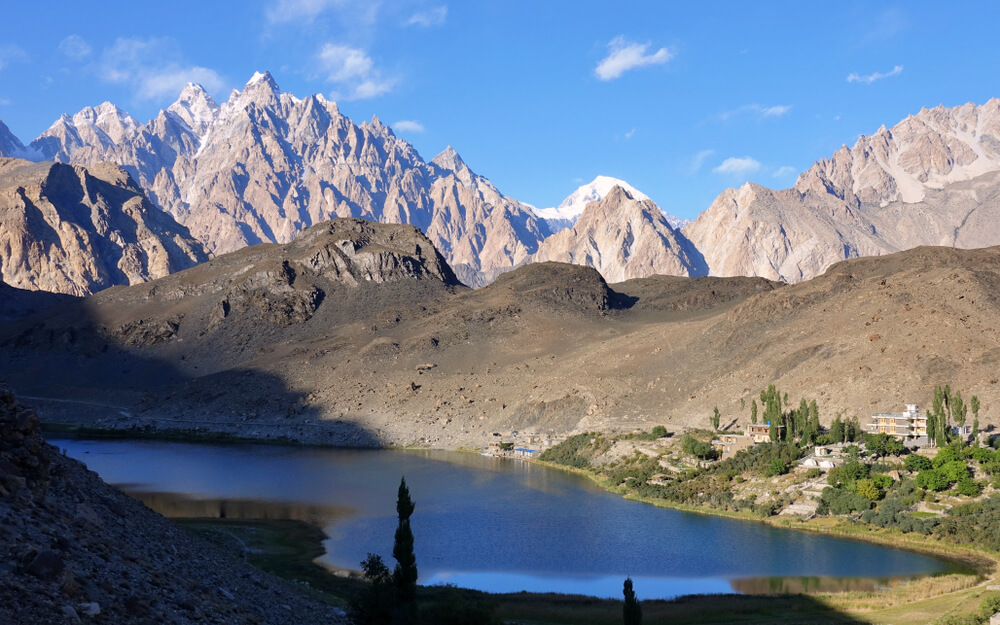
If climbing remote places are your favorite thing, you should not miss the hike from Passu to Borith Lake. This track is located in the beautiful village of Passu.
Being famous for its beauty, the people often turn to this village. However, Passu cones are the main reason for fame.
When here, you can not help yourself but admire the wonder of nature. The mountains, beauty, and scenery will leave you stunned. It is a perfect holiday destination to camp and chill.
On your way to hike, you will encounter a breathtaking view. The best option is to carry a camera and capture the memories. Since it is not a challenging hike, you will have enough time to enjoy the trip.
How To Reach From Passu To Borith Lake
The hike starts after crossing a small bridge over the Passu River. While crossing it, you will start feeling the cold breeze of the Passu River.
Hikers can also over the peaks of the Karakoram range and also the ridge of them. To reach the destination, you have to hike on the same path until you see Passu lake.
The lake is also known as Glacier’s Lake since it is at the end of a Glacier. Once on the top, you can see an 18-km-long glacier. If you continue the journey from the glacier, you will reach Borith Lake.
Difficulty Level Of Trekking
The hike from Passu to Borith Lake is easy and therefore can be completed by anyone fit enough to hike.
Elevation Of Passu To Borith Lake
The elevation of Borith Lake is approximately 2,600 meters above sea level.
Region Of The Mountain
The village Passu (from where the hike starts) is situated in Gojal, Upper Hunza, Gilgit Baltistan.
Best Time To Hike
The best time to hike here is during summer. The entire path is covered in snow during winter and is hard to access.
Do you need a Guide?
No, there is no need for a guide since the path is well-marked and the hike is not tricky.
Chitta Katha Lake
Pakistan is known as a paradise for all hiking lovers. A hike to Chitta Katha lake is living proof of this. With scenic views and thrilling paths, it is among the best hiking places in Pakistan.
The lake is situated in the Shounter Valley of Pakistan. It is not far from Arang Kel (a hill station in Azad Kasmir). However, the hike gets its fame for being able to see Nanga Parbat from a distance.
You might find the hike a little challenging and barren, but the view from the top is worth all the effort you put in. The Chitta Katha lake is a peace straight from heaven.
(It is unlikely that you will get permission to do this hike if you are a foreigner.)
How To Reach Chitta Katha Lake
To get to the Chitta Katha Lake, you must reach Shounter Valley from Kel through a jeep. The track from here is not marked therefore you will need assistance.
Furthermore, from Shounter Valley, you will have to climb food approximately 4000 meters to reach Chitta Katha Lake.
Difficulty Level Of Trekking
Trekking to Chitta Katha Lake is difficult and requires some hiking skills and good health.
Elevation Of Chitta Katha Lake
Chitta Katha Lake is approximately 4,115 meters above sea level.
Region Of The Mountain
This amazing holiday destination lies in Azad Kashmir, Pakistan.
Best Time To Hike
Due to snowfall, the lake is only accessible from July to September. August is said to be the best time to visit the lake. You will get the best scenery during August.
Do you need a Guide?
You will need to have a guide with you for this hike. The track from Shounter is not marked and therefore needs help from someone familiar with the route.
Nalter Valley
Let the magic of Nalter Valley reach your heart. This stunning valley is situated in the west of Rakaposhi. Covered with mountains, this place is among the best hiking places in Pakistan.
One of the most famous things about Malter valley is skiing. It is also called the “Magic Carpet of Pakistan” due to the skiing track. There are many skiing competitions held here during winter.
The village of Nalter is also a beauty to see. It is covered in the pine forest along with the towing mountains. Hikers do not just see the best scenery but a great hike to these mountains.
(NOTE: Skiing competitions are held under the watch of the Pakistan Air Force)
Difficulty Level Of Trekking
The hike of Nalter Valley is easy and requires no expertise. However, you need to be physically fit for the hike.
Elevation Of Nalter Valley
Nalter Valley is 3000 meters above sea level.
Region Of The Mountain
The Nalter Valley hiking track is situated in Gilgit Baltistan.
Best Time To Hike
The best time to visit Nalter Valley is during summer. Being at height, the winters can be pretty harsh.
Do you need a Guide?
You do not need a guide to travel to Nalter Valley. The hike is simple as well as easy.
Kel To Taobat (Gurez Valley)
If you are willing for a few days-long hike, Gurez Valley is the perfect place for you. It is situated between Ket and Taobat. However, the valley is stretched to the Neelum River.
Prepare yourself for a blast of natural beauty and adventure. The track is not just long but challenging. Although it might sound scary, adventure seekers can be found on the route the entire year.
A distance of 25 miles separates Kel from Taobat. You can go there by jeep but walking is the best option. While walking, you get to see some of the best natural beauty in Pakistan.
(TIP: The hike is long and challenging therefore keep the best hiking shoes with you.)
Difficulty Level Of Trekking
The trekking from Kel to Taobat is a little tough and needs you to be in your best health.
Elevation Of Gurez Valley
Gurez Valley is approximately 8127 feet above sea level.
Region Of The Mountain
Gurez Valley in Himalaya mountains, Azad Kashmir.
Best Time To Hike
The best time to hike from Ket to Taobat is during April and September. The weather is bearable and the natural beauty is at its peak.
Do you need a Guide?
There is no need for you to have a guide to hike on this track.
Margalla Hills
If you are looking for an easy climb to start a trekking experience, Margalla Hills is your answer. These hills are among the most hiked tracks in Pakistan. Moreover, the hike to Margalla Hills requires no expertise.
The hills are the best hiking places in Pakistan for those who can not climb up the monstrous mountains. Being no more than 2 hours long, the tracks are among the most famous.
Though climbing Margalla hills is not a tough task, the beauty here is exceptional. There is a lush green forest throughout the track. If you are lucky enough, you might also find a small waterfall here.
(NOTE: There are no snow-covered mountains on Marghalla Hills)
How Many Tracks are there?
Margalla Hills consists of almost 6 tracks. Although all have a beauty of their own, track no.3 is among the most favorite ones. It is the easiest track. You can complete it in less than an hour.
Difficulty Level Of Trekking
Hike on Margalla Hills is beginner-level and can be completed by almost anyone.
Elevation Of Margalla Hills
Margalla Hills is 1,604 meters on its east and 685 meters on its west.
Region Of The Mountain
Margalla Hills are located in Islamabad
Best Time To Hike
The best time to visit these hills is during winter. Summers are hot. One can face difficulty hiking due to the heat.
Do you need a Guide?
No, you do not need a guide to hike on Margalla hills.
Dunga Gali-Ayubia Track
If going on steep tracks or mountains is not your thing, We have a perfect destination for you. Try going on a hike on the Dunga Gali-Ayubia track.
Thai tack is commonly famous as ‘Pipeline Track’. The hike is probably the easiest hike you will ever do. It is a straight track with no climbing. Therefore, people of all age groups can easily walk on the track.
Furthermore, the track takes you from Dunga Gali to Ayubia. A total 4-5km long track is full of natural beauty and landscape to admire. It is among the most beautiful hiking places in Pakistan.
(The track further leads to other hiking tracks as well)
Difficulty Level Of Trekking
Pipeline Track is the easiest hike in Pakistan. Moreover, it is a straight path and requires no skill.
Elevation Of Dunga Gali-Ayubia Track
Dunga Gali and Ayubia Track is roughly 8,200 feet above sea level.
Read more: Best Places to Visit in Galiyat
Region Of The Mountain
The track lies between Dunga Gali and Ayubia, KPK.
Best Time To Hike
The best time to go on the Pipeline Track is during March-April or September-October. The weather is most favorable.
Do you need a Guide?
There is no need for a guide on this track. Moreover, On the track, resting points are located every half kilometer.
Other Famous Places To Go Hiking In Pakistan
Darkot Pass
Darkot Pass is famous for connecting Yasin Valley in Gilgit Baltistan with Boorghill in KPK. The hike to this valley is an amazing experience to have at least once in your life.
Being at an elevation of 4500 meters, you get to see the Darkot Glacier on the hike too.
Charakusa Valley
This valley is famous among those who love rock climbing. There are a lot of rocky mountains in this valley. furthermore, K6 and K7 are the most famous ones. However, being in Karakoram National Park, the place is best for all hikers.
The best time to visit Charakusa Valley is during July and August. The weather is best for mountain climbing.
Tirich Mir Base Camp
Climbing the highest mountain in the Hindu Kush range is an adventure for many. It lies in the Chitral region of Pakistan. Besides, Chitral is famous for its beauty and festivals.
Being at an elevation of 7708 meters, reaching the base camps takes almost a week. Although time taking, hiking is not very dangerous.
Final Point
Hiking/Trekking is like food for all adventure lovers. They spend days climbing dangerous mountains and enjoy every single minute of it. However, you don’t need to go to some place dangerous.
Hiking is an adventure for everyone and all must enjoy it equally. With the list of top ten hiking places in Pakistan, some places interest everyone.
You can either be an expert in hiking or just entered the world of hiking, Pakistan has a destination for you.
FAQs
Which map is best for hiking?
A topographic map is the best map for hiking. These maps provide in-depth details about a region’s physical characteristics. Moreover, topographical maps help identify interesting locations and give hikers information about what to expect.
Which is the easiest hiking track in Pakistan?
Margalla Hills tracks are the easiest hiking tracks for beginners. However, the Pipeline track is also a good option.
Can you track to the K2 base camp in winter?
K2 Base Camp is freezing even during summer. Going in winter can be challenging. With snowfall and freezing temperatures, trekking can be dangerous.
What is the difference between hiking and trekking?
The term trek refers to a journey that is generally more challenging, requires more effort, and generally lasts more than one day. In contrast to hiking, which is categorized as a “walk,” it is usually seen as cheerful, easy, and cheerful.
Is Snow Lake a lake?
In the northern Pakistani district of Gilgit-Baltistan, Snow Lake is a high-altitude glacier lake located in the Karakoram mountain range. However, despite the name, it is not a lake.
Can you swim in Snow Lake?
Swimming in a snow lake is dangerous. The water temperature is freezing. Maybe a few seconds wouldn’t harm much. However, it is best to avoid getting into the water.
Which hiking track is best for beginners?
Margalla hills are the best tracks to start your hiking journey. They are short and require less effort.
However, if you are completely new, the Pipeline track in Ayubia is the better option.
Can I see wild animals during Hiking?
Most of the hiking tracks are away from the human population therefore is a possibility of seeing some wildlife. However, you can see rare birds, leopards, etc during the hike.